Route 85 HANANYA – AMUD Section
Project Name
Route 85 HANANYA – AMUD Section
Field of Activity
Conceptual and Preliminary Design
Specialization
Highways and Expressways
Client
National Roads Company
Location
Israel
Project Duration
1997-ongoing
Project Cost
US$ 45 million
|
Services Provided
|
|
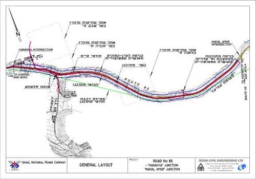
Route 85 is a primary latitudinal highway in Israel's northern region, connecting the located on the Mediterranean coast city of AKKO with the north-west area of the Sea of Galilee. It serves as a key link in the national road network, providing an essential path between the northern coastline and the Jordan Valley area and its neighboring areas. Its total length is approximately 45 km., passing in difficult mountainous topography. Generally speaking, it also serves as sort of a boundary between the Lower and Upper Galilee regions.
Until the mid 1990s the road was operating as an undivided two lane highway. Thereafter, its western section of about 25 km. was upgraded to a dual carriageway with 2 lanes in each direction. Additional eastbound segments of the road are in various stages of similar upgrade design. The project presented below deals with a preliminary design of upgrading a 7.0 km segment of the road – between the HANAYA and NAHAL AMUD junctions – into the said 2x2 lanes facility. |
The typical designed cross section is for a 2x3 dual carriageway in the final stage, despite that in the first stage only 2 lanes in each direction will be constructed. Considering the very extensive excavation and earth moving works, it was decided to implement them already within the first stage, postponing the road widening to final 2x3 lanes cross section for the more distant future.
The preliminary design of the HANAYA – NAHAL AMUD section is carried out in the framework of preparing an outline plan for statutory approval. Furthermore, it consists of a design of an interchange to replace two T type staggered existing at level intersections.
The design of the entire project required addressing of complex topics, such as:
|
|
|
|
TEDEM was chosen as the project principal designer, providing the following services:
On top of all design components performed directly by TEDEM, the company has been coordinating and guiding various sub-consultants in the fields of:
|
Route 85 Upgrade Layout
|
Back