Cross Israel NESHARIM Interchange
Project Name
Cross Israel Highway NESHARIM Interchange
Field of Activity
Final Design
Specialization
Highways and Expressways
Client
DERECH ERETZ HIGHWAYS 1997
Location
Israel
Project Duration
2000-2002
Project Cost
US$ 67 million
|
Services Provided:
|
|
The Cross Israel Highway (National Route No. 6) is a major freeway planned to connect Israel's northern and southern regions.
Operated as a toll road, the freeway runs in its central section alignment north to south between the coastal plain on the west and the hills of Judea-Samaria on the east. In its northern section, the road enters the mountainous areas of Lower and Upper Galilee western region. Down south it is planned to reach the southern outskirts of the city of BEER SHEBA. Its major role is to provide an improved connection between the northern and southern regions of the country without the necessity to penetrate the inner Tel Aviv Metropolitan Area and, at the same time, to enhance their access to the Greater Tel Aviv main business and residential district. In this fashion the freeway offers an alternative route east to the existing two primary longitudinal routes in Israel: Route 4 (GEHA Road) and Route 2 (the Coastal Road). |
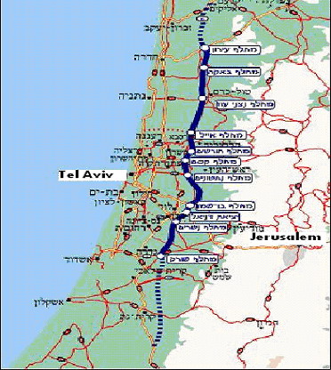
Cross Israel Highway General Layout |
|
|
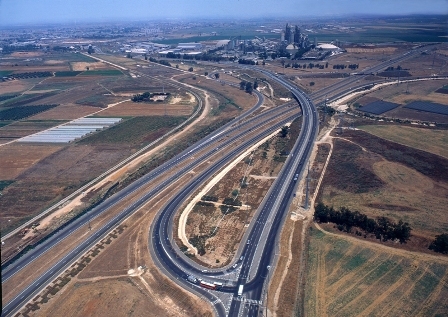
Cross Israel Highway Typical View |
The Cross Israel Highway Corporation is a governmental company in charge of managing the whole project. The DERECH ERETZ Highway Company is the concessionaire for the presently operated central segment and adjacent section under construction.
The Cross Israel Highway is constructed on a staged BOT basis. Out of its final stage spanning for 300 km, its central section of about 100 km has been completed and is already in operation; it has 10 interchanges, 2 tunnels of 300m each and 130 bridges. Additional 60 km are under construction (40 km in southern sections and 20 km in northern section), and the rest is under various stages of planning and design. Parts of the planned northern and southern extension sectors are in various stages of preliminary and detailed design. |
|
|
|
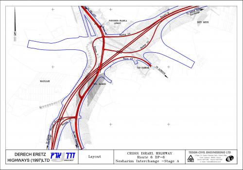
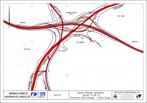
The scope of the project consisted of a 10 km segment of the Cross Israel Highway, integrated with the NESHARIM interchange. This interchange is a complex system junction located south-east to the Tel Aviv Metropolitan Area, in the south-east outskirts of the city of RAMLA. It interconnects the Cross Israel Highway with crossing primary highways (Routes Nos. 44, 431 & 424). A two level structure in its first already completed stage it is designed for a three level complex in the final stage.
The main road is at present a dual carriageway with 2 lanes per direction, with a design speed of 120 km/h. It is designed to be widened to 3 lanes in each way in its final stage. Earthworks were already designed and performed for the final stage configuration, assuming that the additional lane in each direction will be added from the median strip space. |
Interchange ramps have a typical cross section of one lane; some of them will be widened to two lanes in the final stage.
The design of the NESHARIM interchange required addressing of complex issues, such as:
|
|
|
|
TEDEM was chosen as the project principal designer, including the integration of all other multidisciplinary consultants participating in the planning process. Within this framework the company has been providing the following services:
|
On top of all design components performed directly by TEDEM, the company has been coordinating and guiding various sub-consultants in the fields of:
|
|
|
|
NESHARIM Interchange Layout (Stage 1 - completed 2002) |
NESHARIM Interchange Layout Final Stage (Preliminary Design) |
Back