GAZA – WEST BANK Transport Link
|
Services Provided:
|
|
|
|
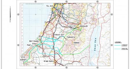
The Palestinian Authority (PA) territories cover, at present, the Gaza Strip located on the Mediterranean Coast and selected zones of the landlocked West Bank. These two regions are separated by the northern part of south of the State of Israel. At present there is no direct connection between the two PA regions. Travel of people and goods in both directions obliges entering Israel, which is severely restricted and often obliterated for security reasons. |
Bearing in mind the high level of uncertainty regarding a time span for more stable geopolitical situation in the region, USAID commissioned a feasibility study for linking the two PA geographically separated regions in order to identify possible alternatives for a transportation corridor between them. It has been assumed that the existence of such a direct connecting corridor would significantly support economic development of the PA two parts, thus moderating the regional tense political conditions. |
|
|
|
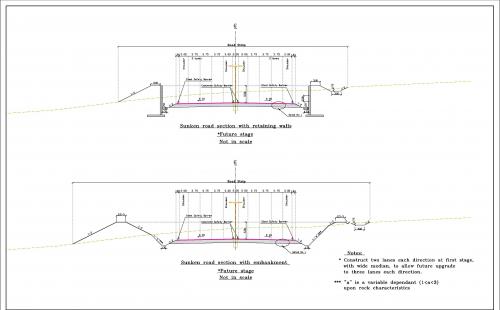
Typical Sunken Road Cross Section
(derived from selected alternative) |
Tunnel Cross Section
(derived from selected alternative)
|

|
TEDEM provided various consulting services regarding specific surveys and analysis, familiarity with local conditions and coordination with local agencies and bodies. |
Back